The Village of Warfield, BC, is a small, mostly residential community in the West Kootenay region of British Columbia with a stable population of 1,680 people. It is close to the City of Trail, BC, where Teck Resources, one of the world’s largest integrated lead-zinc smelting operations, has an office. The village was first established in the 1930s to create homes for the families of workers in the thriving mining industry located nearby, and much of its infrastructure is aging and in need of replacement.
Warfield’s council and administration recognized the need to be proactive in managing the village’s infrastructure. The village started to adopt asset management formally in 2017 when it accessed funding from FCM’s Municipal Asset Management Program (MAMP) to strengthen the asset data and information that is the foundation of its asset management program. MAMP has approved grant funding to over 70 local governments in BC for various asset management projects.
Captured data for linear assets including roads, and water and sanitary systems, and determined replacement costs over a long-term time horizon (30 years).
Established a cost-effective model for managing asset data, using open-source asset management software and ongoing technical support.
Developed a peer-learning network with neighbouring municipalities that supports ongoing knowledge sharing and collaboration.
The challenge
The village has limited capacity to undertake asset management. Its small team of five includes three office employees, with the corporate officer as the only management position. The other three are front-line public works team members managing the day-to-day operations and maintenance of the infrastructure the village owns and manages.
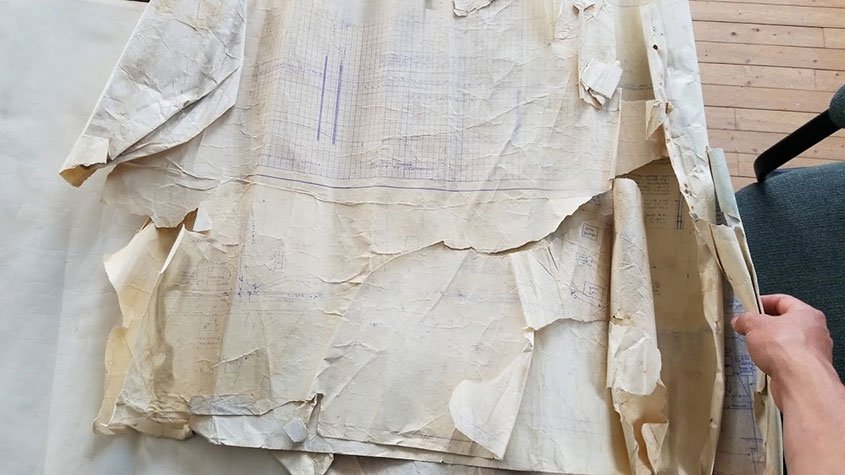
Prior to undertaking the project to strengthen asset data and information, the public works team members, all three of whom are approaching retirement age, were using handwritten notes in binders to document information about the village’s assets. While the village had some paper maps showing the location of some linear assets, and engineering documents that showed the location of other assets, the data was not well-organized and there were many gaps in key attribute data like the size, age and condition of the assets. Some data only lived in the head of the public works manager.
Before this project, paper maps like these held much of the information about Warfield's linear assets. (Image source: Village of Warfield, BC)
While staff and council recognized the need to better track the asset data and modernize the system, staff did not have the expertise or time to collect the data, map the assets and create a digitized asset register.
The approach
Warfield accessed technical support from the same consultants that were being contracted by five neighbouring municipalities—LandInfo Technologies, a geospatial and asset management consulting firm. The firm digitized and mapped all the key attribute data for the village’s linear assets, using the steps outlined below.
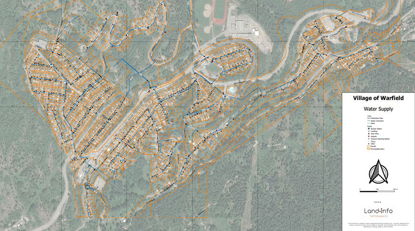
Step 1: Identify, digitize and map existing asset data. The consultants captured all the data identified in Warfield’s paper documentation of the village’s assets and logged it in a digitized asset register using QGIS, an open-source geographic information systems software, by validating the locations of the assets identified on the maps and geo-referencing them. The village was also able to tap into the expertise of the local college, Selkirk College, contracting students to collect and map asset data.
Warfield now has a digitized and mapped inventory of assets. (Image source: Village of Warfield, BC)
Step 2: Eliminate data gaps. The consultants met with Warfield’s public works team several times to identify the location of assets that only staff knew about because they had never been formally documented.
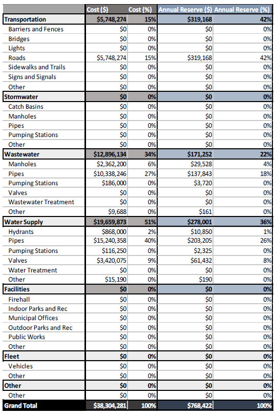
Step 3: Generate a preliminary “state of infrastructure” report. Once Warfield had a relatively comprehensive data set and digitized asset register, it used AIMsoir, a free, open-source asset management software, to generate a preliminary “state of infrastructure” report that listed the assets owned by the village and their estimated replacement cost (see Relevant Resources below).
Warfield's Preliminary State of Infrastructure Report. (Image source: Village of Warfield, BC)
Step 4. Maintain and enhance asset data over time. For the Village of Warfield, the most cost-effective way to manage its asset data over the short to medium term was to contract the consultants to maintain and update the digitized register on an ongoing basis. Warfield pays a nominal web hosting fee to the consultants to manage its domain using the free, web-based, open-sourced asset management software tool. Warfield also pays the consultants to maintain and update the data as required when new information becomes available.
Step 5. Train employees on use of the asset management system. Staff have taken training that will support them in making the best use of their asset management information. The training covers a range of topics, beginning with awareness raising about the concepts and principles of asset management. Staff learn how to use the most relevant features of the software to support analysis of the state of infrastructure and make decisions about priorities. The training is less about the technical requirements for updating and maintaining the data and more about understanding how to use the information contained in the system to present to council and support decision-making.
Results and benefits
A fully digitized asset register: Warfield’s mapped inventory includes key attribute data (e.g. install date, pipe diameter, pipe material, pipe length). Its “state of infrastructure” report includes life expectancy, condition, and replacement costs for the next 30 years for roads, the water distribution network, sanitary network, stormwater network, buildings and the water treatment plant. Capturing the linear asset data was an important first step in strengthening asset management, laying the foundation for planning and decision-making.
A system built on open-source asset management software: The support that the village received in accessing and using open-source software was essential for a small municipality with a limited budget and staff capacity. The project would not have been feasible with additional software costs. These savings mean the municipality can invest in other priorities.
Making best use of resources: Having the consultant host the village’s domain and update the data is currently the most cost-effective solution for the village. When compared to the cost of a full-time geographic information systems analyst or asset management technician, this approach leads to a substantial savings for the village and minimizes the risk associated with potential turnover of highly skilled employees. The village can also decide to take the work in-house anytime if resources permit.
Better-informed decisions: Council relies on Warfield’s Capital Infrastructure Advisory Committee to provide advice on strategic directions for capital and operational improvements and spending. The committee is appointed by council and composed of two council members and three or more community members that are deemed to have valuable education or experience in asset planning or infrastructure assessment. With improved data and information about the state of the village’s assets, the committee is better equipped to provide strategic advice to council.
A standard approach that supports peer learning and networking: Warfield and five neighbouring municipalities are supported by the same consultants, using the same open-source software. Their asset information and registries are based on a standardized structure, codes and language that enables them to compare and relate to each other’s challenges. The municipalities meet regularly to discuss and troubleshoot key infrastructure challenges like water treatment or sewer issues. They have also participated together in asset management training offered by Selkirk College in conjunction with LandInfo Technologies.
Access to infrastructure funding: An additional benefit of the project is that Warfield is able to demonstrate progress in asset management, a requirement to access federal and provincial funding for infrastructure projects. This is critical for Warfield as it is planning a major investment in new infrastructure needed to deal with a water supply issue. By 2026, the village will need to supply its own raw water from the Columbia River and to do so it will need to construct a new pump house. The raw water has historically been provided by Teck Resources, but that agreement is coming to an end.
“The cost of underground infrastructure is a big lesson learned for me and the effort to track and manage our assets. When we have a major issue, I’m out there taking pictures. And then we investigate to determine if we were accurate about the type of material, the exact location of the assets. Everybody wants their running water and their household to function smoothly, but it takes a lot of key components to make that happen.”
– Jody-Lynn Cox, Chief Financial Officer/Corporate Officer, Village of Warfield
Lessons learned
External technical support can be an affordable way to leverage employee knowledge without adding significantly to workloads. The village was pleased to find a cost-effective solution to building a modern, digitized asset register that will improve operational efficiencies and lead to more strategic decision-making. The approach built on the considerable knowledge of public works employees while enabling access to technical support that was not available in-house. The task of documenting and digitizing data may very well have been pushed to the side without external technical support.
Knowledge-sharing and collaboration adds value. The village also recognized the benefits of collaborating with other similar-sized communities on asset management and has discussed the potential of creating a collaborative asset management project with neighbouring communities to create economies of scale.
Asset management is a process of continuous improvement that takes time and commitment. This project was an important first step in digitizing the village’s asset register. Warfield recognizes that further work is needed to determine the condition of and risks to its assets before the village can start prioritizing activities and projects.
Next steps
Warfield progressed on asset management to a point where it had general information on the state of its infrastructure, including the expected replacement costs for its assets. As is often the case for local governments, the expected replacement costs exceed the funds that Warfield currently has available in reserve. Water services currently need the most attention. The most important next step will be to identify the village’s critical assets so that it can begin to prioritize and develop budgets accordingly.
After completing the MAMP-funded project, LandInfo Technologies helped Warfield migrate its asset management data and information into a new open-source asset management platform, which makes use of a database to store asset data instead of spreadsheets.
Warfield also received funding from the Union of BC Municipalities to assess risks to key infrastructure assets, and has ranked its assets in a risk assessment matrix. The matrix includes risks posed by climate change to engineered assets. Risks to natural assets (such as wetlands and riparian areas) are anticipated to be addressed in the future. The risk matrix is being used by Warfield’s Capital Infrastructure Advisory Committee to identify priorities. Warfield’s next step will be to develop a long-term financial plan for asset replacement.
Contact
Jody-Lynn Cox, Chief Financial Officer/Corporate Officer, Village of Warfield
Telephone number: 250-368-8202
Relevant resources
The Village of Warfield used AIMsoir, a free, open-source asset management tool produced by the Atlantic Infrastructure Management (AIM) Network. It used the tool to generate a preliminary “state of infrastructure” report that summarized the state of the assets owned by the village and their replacement costs. The AIMsoir tool is now a component of the AIM Capital Planning Tool, which supports a municipality in developing its capital asset management program. To learn more about the Capital Planning Tool, visit aimnetwork.ca, and contact info@aimnetwork.ca for access to the latest version.
Guide: Questions to ask before your municipality considers asset management software
Questions to ask before your municipality considers asset management software.
Tips for working with an asset management consultant
Is your municipality thinking of hiring an asset management consultant? Discover tips that help you avoid challenges, get the most value and articulate what you need to make your project a success.